Tag: National Parks
-

A Museum Where The Telegraph Is Alive And Well And Still On-The-Air
They report for duty in uniform — khaki shirt, name tag over the left breast shirt pocket, and a cap with an embroidered emblem that looks like lightning bolts. A patch on the left sleeve identifies who they are: National Park Service Volunteer. They’re surrounded by electronic relics— most still working— that take up space and make a lot of noise.

Before the Internet, email, and satellite communications changed our lives, there was the telegraph—the lifeline of dots-and-dashes called Morse code, transmitted over the airwaves so ships at sea could talk to land-based radio stations. There were hundreds around the world and dozens in North America. Most have disappeared, with only one still on-the-air in North America— KPH radio station, San Francisco. The NPS volunteers are keepers of the faith, inside an art deco style building at the end of a long road canopied by Calfornia cypress trees on Point Reyes National Seashore.

KPH Radio Station/Point Reyes In the heydey of the telegraph, mighty RCA (Radio Corporation of America) owned KPH. Before moving to Point Reyes, KPH first operated from San Francisco’s Palace Hotel in 1905. A year later the Great San Francisco Earthquake struck and forced the station to relocate. It was regarded as the “wireless giant of the Pacific.” The station received incoming telegraph messages from its transmitter in nearby Bolinas, California, including the infamous message of December 7, 1941— the Japanese invasion of Pearl Harbor. At the time, Morse code was the only way ships could send distress signals. It was the standard ship to shore communication for 100 years, eventually replaced by advances in electronic communications technology near the end of the 20th century.


The last Morse code ship messages to and from KPH ended on June 30, 1997. The National Park Service then stepped in and took over the KPH property. The building was shuttered for two years before Richard Dillman, president of the Maritime Radio Historical Society—a small volunteer group of self-described “radio squirrels”— convinced the National Park Service to let them bring KPH back to life. The non-profit group pays for the operation through small grants, donations, fundraisers, and money out of their own pockets. Dillman says he and others in the group find creative ways to fix and maintain some of the electronic relics. After all, spare parts are hard to find. A storage room inside KPH is a trip back in time as shelves are stacked with vintage radio receivers. Before the coronavirus pandemic, visitors to Point Reyes National Seashore could visit the KPH building every Saturday for tours, and observe volunteer radio operators communicate via telegraph over open maritime channels to the few ships around the world still equipped to send and receive telegrams. Now the KPH radio building is closed and will remain that way until California moves to phase 3 COVID-19 reopening. The state is currently in phase 1. Still, the closure has not deterred the KPH volunteers, according to Roy Henrichs, who heads operations and maintenance for the Maritime Radio Historical Society. “We are working to resume transmitting Morse broadcasts on maritime frequencies from an alternate transmit site in Valley Springs, CA, ” explained Henrichs via email. “That is experimental development work, but initial testing began last Saturday (September 5, 2020). That should keep us on the air through the end of the COVID event, as well as any future event that takes us off the air at Point Reyes.”
A dedicated bunch of radio squirrels doing whatever it takes to stay on-the-air and preserve history.
KPH PHOTO GALLERY


-

A Popular Old Lighthouse On The Edge Of The Pacific Gets A Makeover


You can appreciate what it took to help ships navigate the rocky, fog-shrouded, and windswept northern Pacific coast when you journey far out to the isolated Point Reyes Lighthouse. It is a hike to get there. From the parking area at Point Reyes National Seashore, you first ascend a steep paved walking path and then descend a long winding stairway of more than 300 steps – the equivalent of a 30-story building. The trip back will tax your legs and raise your heart rate. Consider this before you go: The walk down to the lighthouse takes between 5-10 minutes; the return trip up is approximately 20-30 minutes or longer depending on your fitness level. At the top of the stairway, the lighthouse appears as a mere speck on the horizon. This no man’s land surrounded by water had no mercy on the human spirit. Lighthouse keepers spent lonely days perched on a cliff at the western tip of Point Reyes that juts 10 miles out into the sea. No other lighthouse in America experienced more fog and wind than Point Reyes. It still stands as a beacon in the Pacific nearly 150 years after it became operational in 1870. Until the lighthouse was retired by the U.S. Coast Guard in 1975, keepers occupied and maintained the house, the machinery, and the powerful Fresnel lens that alerted mariners.

FRESNEL LENS/NPS PHOTO The lighthouse surely prevented casualties at sea, but not all. Over 50 shipwrecks still occurred, killing countless crews and passengers. Since the lighthouse has historical maritime significance, an ambitious full restoration project kicked-off in early August 2018. It took 13 months to complete and cost $5 million. Restoring the huge Fresnel lens was the centerpiece of the project. This required specialized work from a lampist who disassembled, repaired, and reassembled the lens’ 1,032 original crystal pieces made in Paris. The lighthouse’s observation deck is open to the public and is a great place to watch for marine life, especially gray whale migrations during winter and spring. If you love history, nature, and don’t mind an aerobic workout along the way, plan at least a half-day excursion out to the Point Reyes Lighthouse. Click the video below to learn more about the life of a lighthouse keeper, a behind-the-scenes look of their workplace, and the challenges they faced.
If You Go…

NPS PHOTO Bring your own food and water.
Wear comfortable walking/jogging shoes.
Wear layered clothing for fast-changing weather conditions, including fog and rain.
Cell phone service is limited and sometimes non-existent.
Pets are not allowed beyond the parking area.
Public restrooms are available.
Map Your Journey…

-

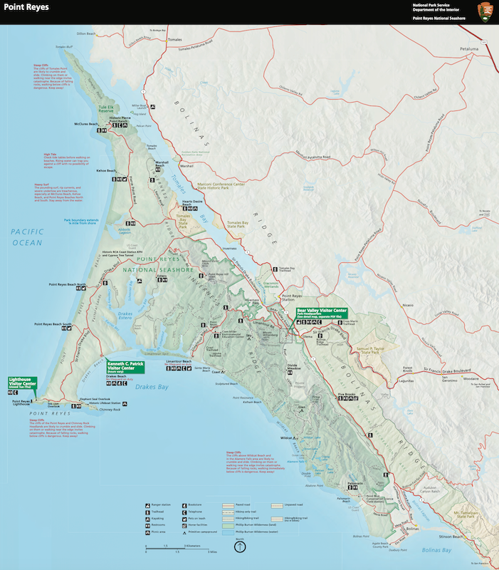
Point Reyes National Seashore Is On Shaky Ground In Northern California
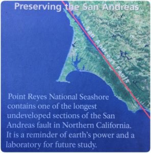
NPS Photo One of America’s most natural wonders sits directly in the path of one of the world’s most well-known earthquake zones: the San Andreas Fault. Point Reyes National Seashore has spectacular beauty, abundant flora and fauna, and magnificent coastal cliffs. Yet the ground under it all is constantly on the move.

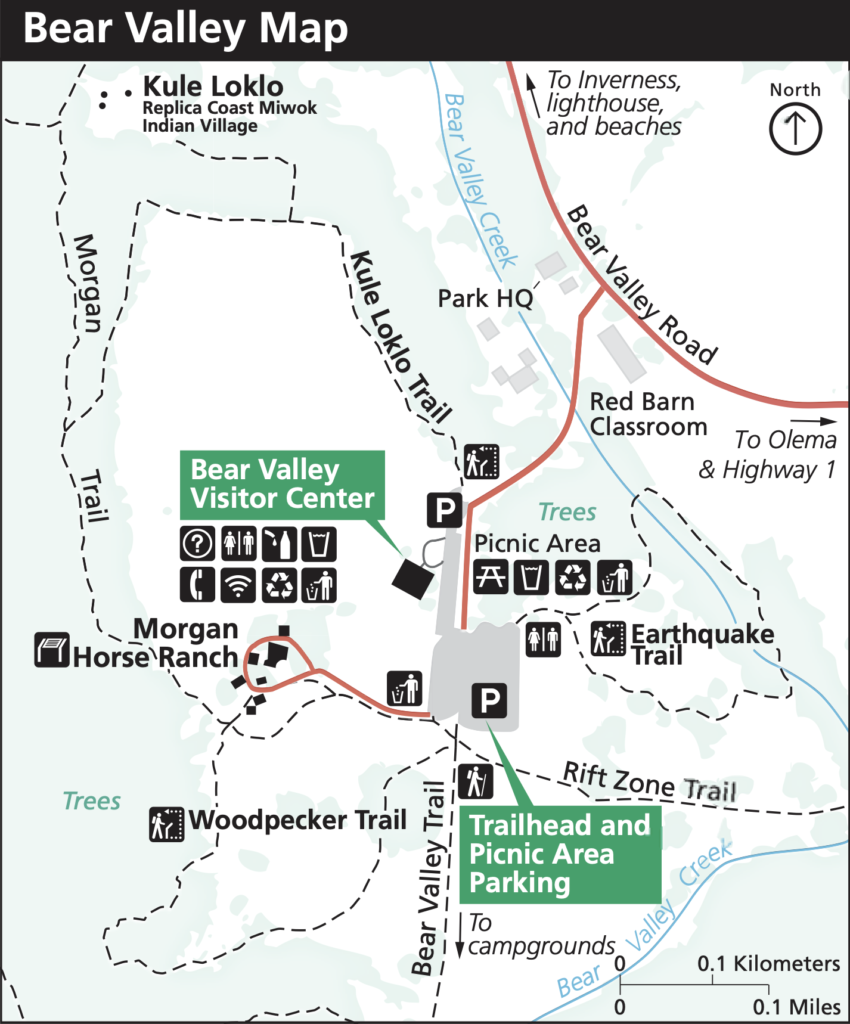
Earthquake Trail San Andreas Fault Marker The San Andreas Fault is the tectonic plate boundary between the Pacific Plate and the North American Plate. That plate boundary slowly moves an inch-and-a-half to two inches a year — about the same speed a fingernail grows. The last time stress between the two plates built-up and slipped was 1906, which caused the Great San Francisco Earthquake. The quake remains the worst natural disaster in California’s history. More than 3,000 people died and over 80% of San Francisco was destroyed. The San Andreas Fault is approximately 750-miles long and runs through most of California. At Point Reyes National Seashore, you can hike the Earthquake Trail, an easy paved loop around the fault zone. The trail is less than a mile and has signs posted with information about the fault line’s history and impact on the local landscape. Earthquake Trail is just a short walk from the Bear Valley Visitor Center.

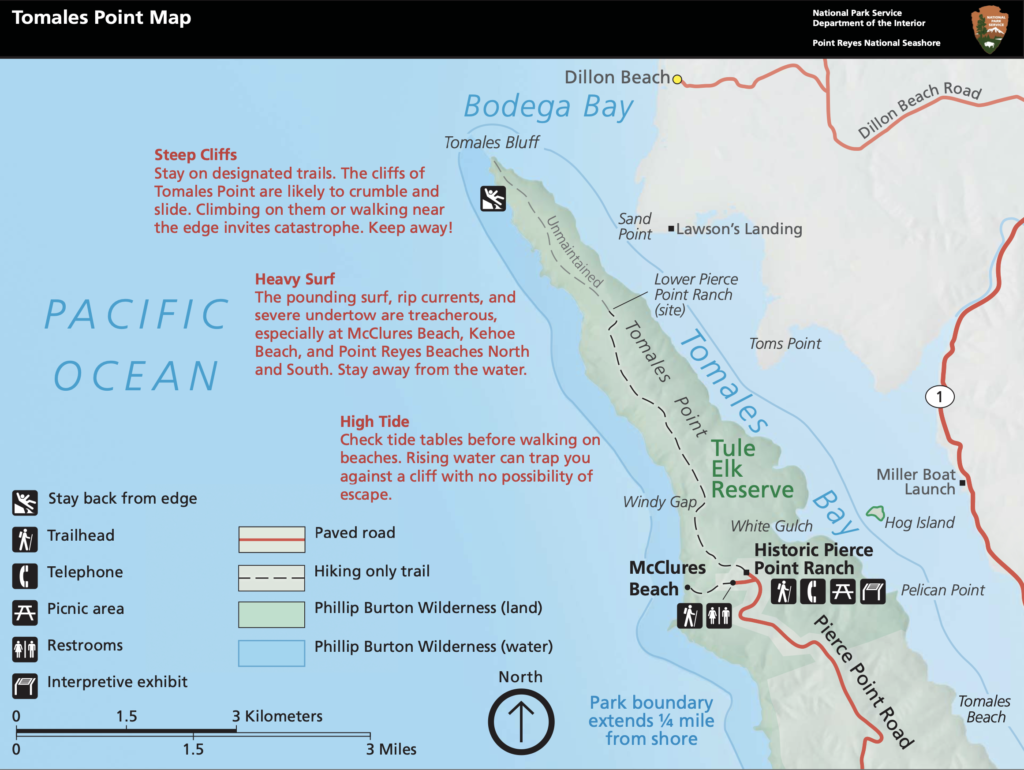
Tomales Point Trail The Tomales Point Trail parallels the fault line. While hiking Tomales, you’ll likely be awestruck by the stunning scenery along the peninsula. On one side is Tomales Bay; the other is the Pacific Ocean. The one-way trail is approximately nine miles roundtrip, but you don’t have to hike all the way out to Tomales Point, where the trail becomes more rugged.
 There’s only a slight elevation during the first several miles.
 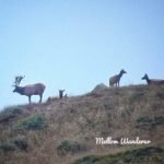 Stop and admire the wildflowers, especially in spring and summer when they are in full bloom. Along the way, you’ll probably see a herd of free-range Tule Elk. The herd grazes near the trail, but hikers are advised not to approach or disturb them. It’s best to stay on the trail the entire time. Tule Elk are only found in California. Tomales Point is a 2,600-acre reserve for the Tule Elk to roam. About half the herd is less than five years old. The best time to view elk is between August and October during mating season. You can often hear bull elk bugling from the top of the hills as they round-up females. Bring binoculars and a camera with a telephoto lens for great close-up views and pictures.
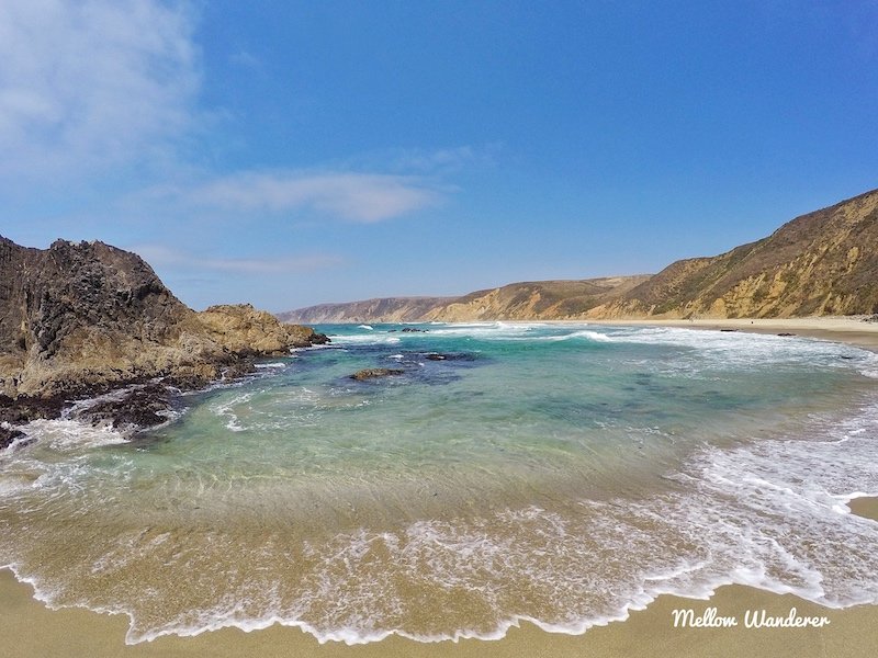
McClures Beach From the same Pierce Point Road parking lot where you enter the Tomales Point Trailhead, you will find another hiking trail descending to remote McClures Beach, a small cove hugged by towering rocky cliffs.
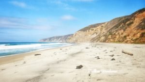 The hike is about a half-mile and follows a meandering creek down to the beach. Walking along the water’s edge is peaceful, refreshing, and mostly isolated. You can explore tidepools, or just sit on the beach and drink in the fabulous views. If you go for a swim, beware of rip currents and sneaker waves.
 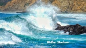 A sneaker wave happens suddenly and is higher, stronger, and extends farther onto the beach than a normal wave. There are no lifeguard stations. The surf here is alluring, but intense, so stay alert. Also, be cautious of the cliffs and bluffs while on the beach. They can be unstable since they’re formed of soft rock and are vulnerable to landslides and rockfalls. You certainly don’t want to setup a beach camp next to the cliffs. Save enough energy at the end of your beach day for the half-mile ascend on the trail back to the parking lot. (Click the video below for scenic views of McClures Beach and the Tomales Point Trail)
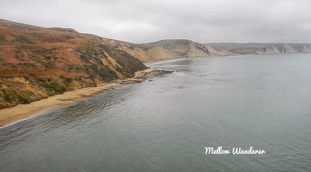
Chimney Rock Another popular trail is Chimney Rock, where Drakes Bay and the Pacific Ocean meet. This is a relatively easy hike of less than two miles. Keep a lookout for gray whales, as the waters here are popular migration routes and feeding grounds.
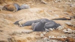
Elephant Seals Take the trail to the Elephant Seal Overlook. These incredible sea mammals almost became extinct at the turn of the 20th century due to overharvesting. Back then, their blubber was a popular source of fuel. Once protections took hold, elephant seals returned to Point Reyes in the 1970s. The population bounced back in a big way. There are now over 3,000 elephant seals at Point Reyes National Seashore. Chimney Rock is an excellent viewing area.
Map Your Journey
(Click The Title Below Each Map For A Full Screen View)
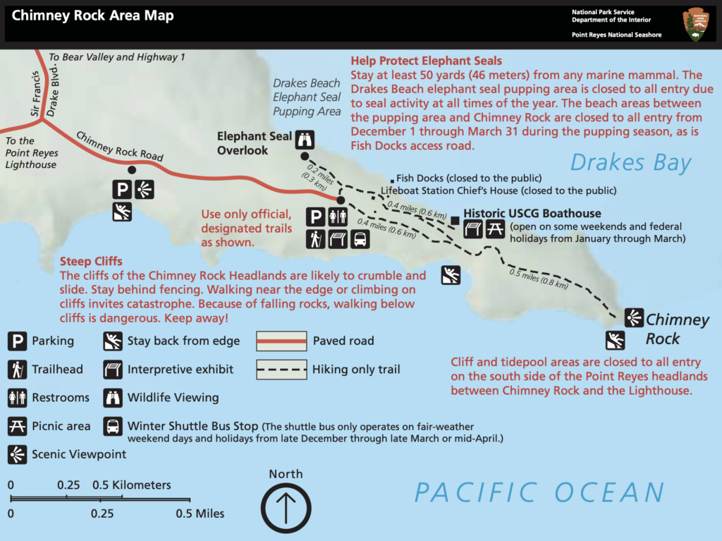
Chimney Rock/Elephant Seal Overlook -

Majestic Windjammer Parade Celebrates A National Treasure
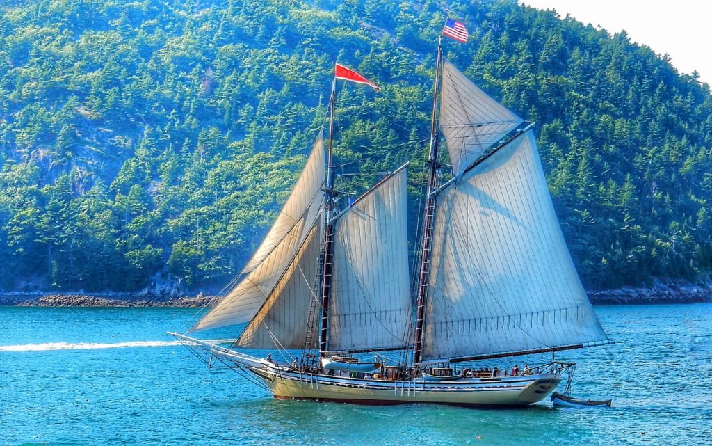
(MT. DESERT ISLAND, MAINE) Crowds gathered on the banks of Somes Sound in the heart of Acadia National Park for a maritime show of multi-masted sailing vessels in honor of Acadia’s 100th anniversary. The Maine Windjammer Association organized the August 2nd parade of North America’s oldest fleet of commercial schooners, all escorted into the mouth of Somes Sound by dozens of yachts, sail boats and other vessels.
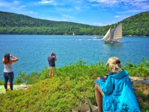 On a cool, breezy sunny afternoon, full-sail schooners gracefully glided through the water, making several passes around the Sound to applause from hundreds of enthusiastic spectators, who gathered hours earlier to park along the waterfront off Sargent Drive.
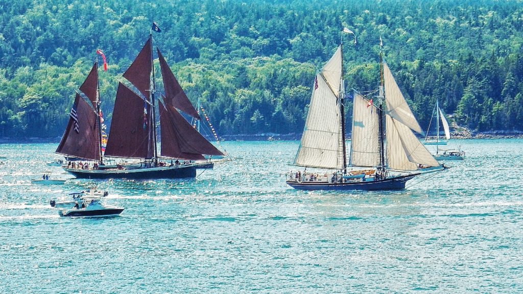
 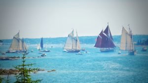 The Lewis R. French was the grand old man of the parade. Built in 1871, the French is a National Historic Landmark and is the oldest Windjammer in America.
 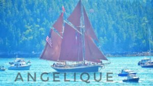 Over its life the vessel has transported fish, coal, lime, bricks and today up to 21 paying passengers on vacation. The 95 foot Angelique was built in 1980 and can host 29 passengers . According to the Maine Windjammer Association , the Angelique is patterned after the 19th century sailing ships that fished off the coast of England.
 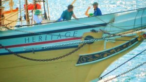 The Heritage was built three years later, carries 30 passengers, and has its home port in Rockland, Maine. The boat was built in the tradition of a 19th century coaster. The American Eagle has a unique and rich history. Built in 1930, the Eagle spent more than 50 years working the sea as a member of the famed Gloucester, Massachusetts fishing fleet. The boat is designated as a Windjammer National Historic Landmark.
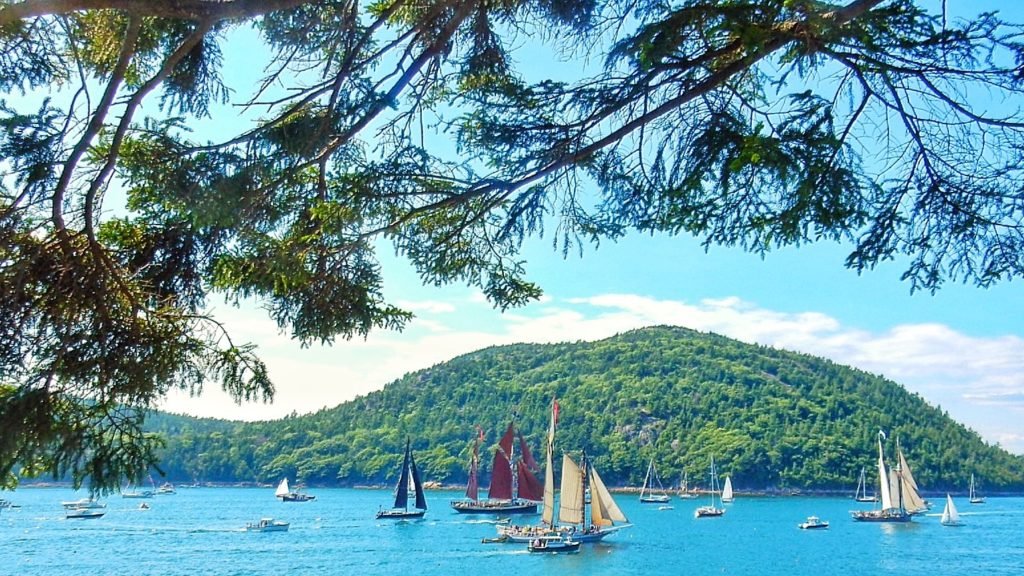
The Isaac H. Evans is steeped in tradition and history. Built in 1886, the Evans is observing her 128th anniversary. Her roots trace back to America’s fishing industry, and also has National Historic Landmark designation. Her deck is 65 feet in length and can carry 22 passengers.
The Ladona originally sailed in 1922 in Boothbay Harbor, Maine. It was built as a pleasure yacht for the Loring family. The schooner won the 1923 Bermuda’s cup in her class. Ladona served in World II assisting the US Navy as a submarine patrol. Today, Ladona accommodates up to 16 guests.

The schooner parade was just one of many events celebrating the centennial anniversary of Acadia National Park.